In order to understand the Baeza of today, we need to go back to the first settlers, and see how from those settlements the city was forming-- until it became a medieval walled metropolis, due to a privileged geographic-defensive location.
The well-known Square of the Lions or the Pópulo’s is one of the most import squares in Baeza. Reorganization was finished in the 70’s, when some of the urban elements were relocated. Before this new distribution, the notorious lower-square was an extension of the Square of the Market or Stroll.
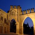
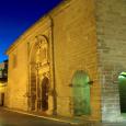
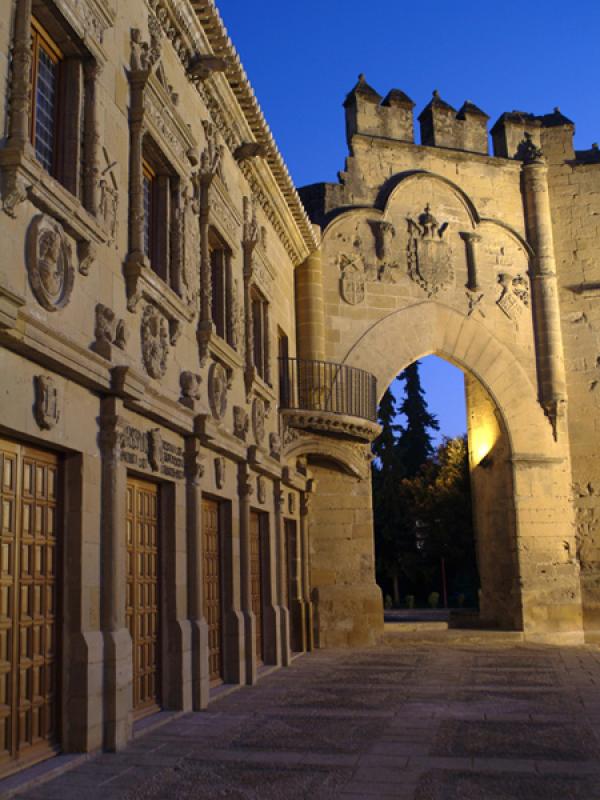
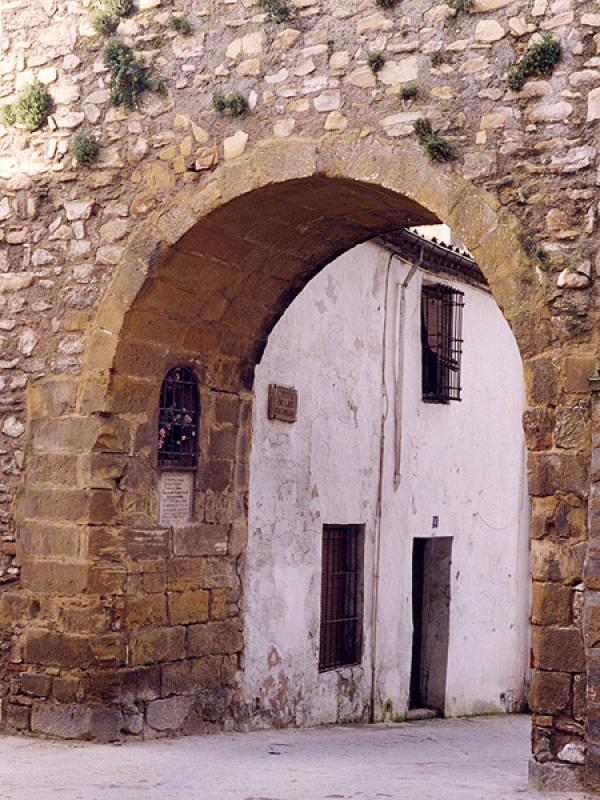
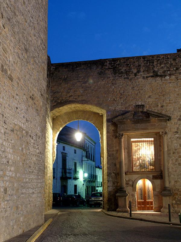
The Gate of Azacaya or Jaén is one of the examples spread through the urban fabric of what once was the medieval walled city. The place where the gate is located was the required way to exit the city towards Jaén, and also the place from where the troops set off to conquer the last Muslim bastion.
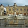
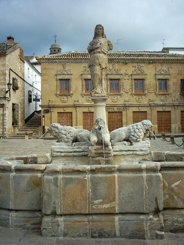
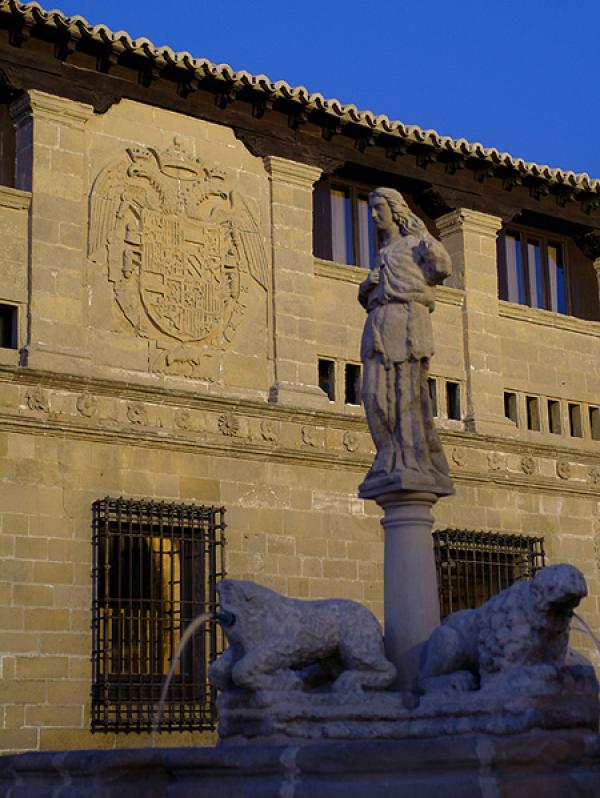
During a great part of the 16th century, this was the main fountain of the city, also known as the basin. It is a mixtilinear basin fountain with curves at the corners, which has two pairs of felines and equines, and a classic feminine figure on top of the column.
This was built around 1535. The wall next to the Gate of Jaén had to be torn down, with the condition of not destroying the chapel of the Virgin of the Pópulo, consolidated as a memory of the first mass that was held after the conquest.
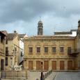
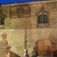
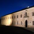
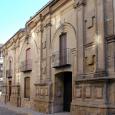
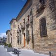
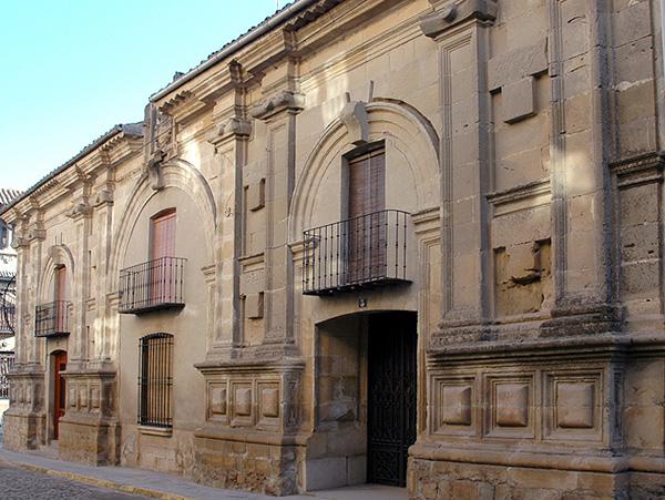
This building was built during the reign of Charles I. Located originally on the city outskirts by way of the Gate of Jaén, it was relocated in the 70’s, by the General Administration of Fine Arts-- to its current location, in order to establish a regular and organized square. The building couldn’t be rebuilt with the same configuration, since the square was shorter than its original emplacement, so the solution was to double the ends folding them over the sides.

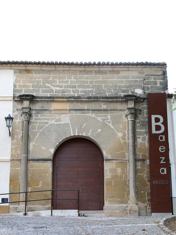
The origin of the foundation came from the figure of St John of Ávila, who established, under the title of “the Most Holy Trinity “, the Learning Institutions or Schools of Literature, which in 1542 were transformed into a University, which became the most important in Andalusia. The relocation happened in 1568, leaving this building as a primary school until 1814, when it became a tenement house until 1992, the year in which the Town Hall restored part of it for accommodation and the rest for the Baeza Museum.

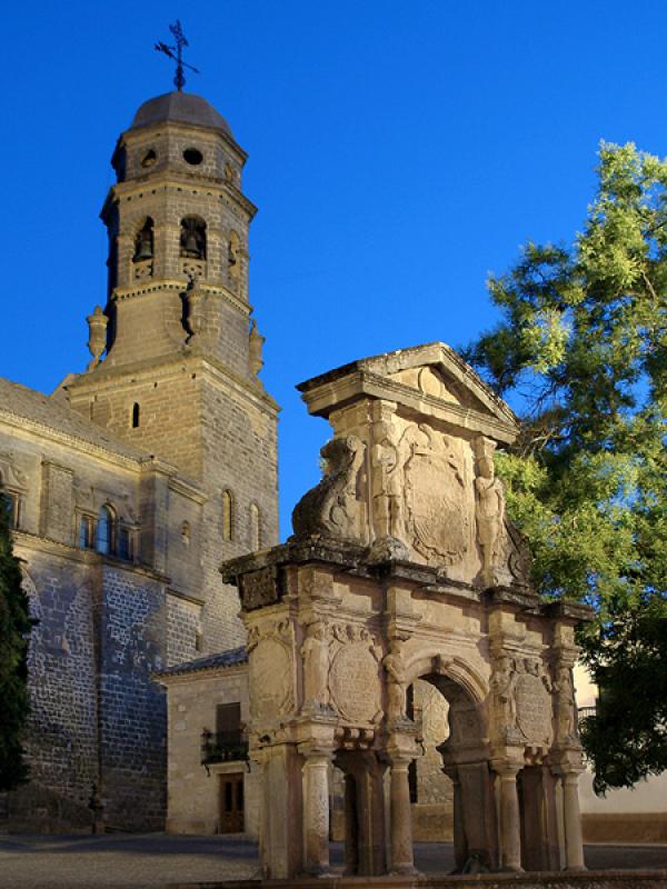
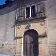
This arch was another access to the city, also known as the Gate of the Learning Institution or the Shutter of Saint Lion, since it is now where the University is now situated. It used to be the location of the chapel of Saint Lion. The name “Bearded man” is due to Martín Yañez of the Barbuda, master of the order of Alcántara, who in 1394 walked through that gate with an important army to fight against the Muslims from Granada, according to the testimony of the oral traditions.
The second University headquarters, was erected in the same place where the chapel of St Lion was situated, to solve the space problems that existed at the first location. The building was finished in 1593, and kept its purposes until 1824 when it was permanently lifted by Royal Decree. Later it was a Humanities School and Free Institute, where Antonio Machado gave classes. Lastly it turned into a Secondary Learning Institution.
This construction from the 16th century and created by The Crown, was located in back of the Corn Exchange. The two buildings were connected and this one served as a grain warehouse.

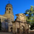
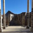
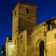
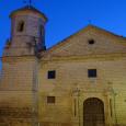
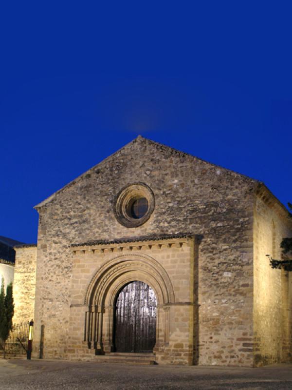
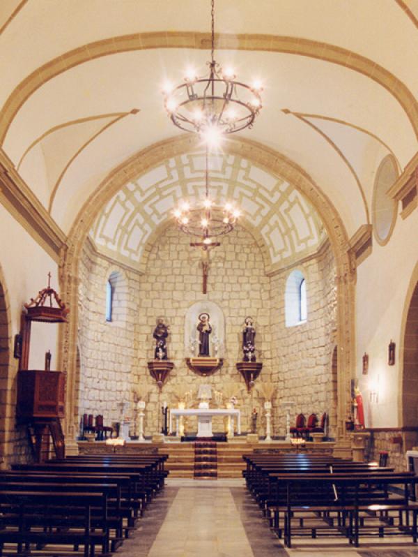
This church of late Romanesque style dates from the 13th century, which is still preserved after the Christian conquest. It has an austere exterior, with two gates standing out with semicircular archivolts. The main part comes from the old Church of Saint John the Baptist.
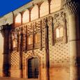
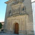
Opposite the Church of Saint Cross rises the Palace of Jabalquinto, one of the greatest examples of Elizabethan Gothic style, which was commissioned by John Alfonso of Benavides, second cousin of Ferdinand the Catholic, in the late 15th century.
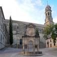
The Cathedral is the most representative building in the square. It is believed that, in this location, a Romanesque temple could have existed, later transformed in Visigoth style until the arrival of the Muslims who built the Aljama mosque. In 1227, it became, under the dedication to the Virgin Mary of “The Nativity”, the Cathedral site.
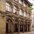
This is a building from the late 15th century, the property of “Hill” Bayle of Cabrera, who gave it away to the Council to house the Town Hall. In 1838, it became the local archive until 1970. In 1991 it became a conservatory, now it is closed waiting to be restored soon.
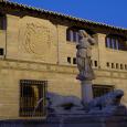
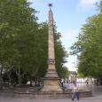
We are standing at the civilian and religious area of the city at that time. That is why this large fountain was built--for the commemoration of the bringing of water to Baeza, as an arch of triumph of Ginés Martínez of Aranda in 1564.
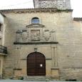
The seminary was founded in 1660 by Bishop Ferdinand of Andrade and Castro under the management of the Fathers of Saint Philip Neri Oratory. In 1921 the major seminary was moved to Jaén and in 1969 the seminary was permanently closed. In 1990, the building reopened as Antonio Machado University.

This palace, dated in 1804, was built by Joseph Cayetano Rubín of Ceballos and it is a sample of Baeza neoclassical architecture.
Some remains still stand from the late Romanesque temple that became at that time, one of the most important parish churches within the city walls, as we see in its naves and apse.

It was without a doubt the best fortified gate from all the walled city. It led to the Úbeda pathway, and in front of which there was a big main square.
The Jesuits arrived in Baeza in 1570 and started to build a school having their first headquarters on Mine Street. Years later, due to space problems, they moved to their current location.
This is one of the most important towers in the Muslim walled enclosure from the 12th century. This is due to its strategic location, since from this tower there was a straight line of sight of the barbican and the torn-down Gate of the Cañuelo (in the current Company street).
The Corn Exchange is a foundation and local control building. It was erected in the 16th century to give response to the social and economics necessities at that time.

In 1684, judge Ferdinand Ladrón of Guevara proposed to the town council “Look for a place from which to watch bull festivals and to build comedy houses”. Finally after many difficulties this small building is inaugurated in 1701, with a double semicircular arch gallery, with paired columns with a background of Doric capitals. It was a balcony from where bull fights and others festivals could be admired.
In order to understand the glorious period of Baeza, we need to enter the different neighborhoods which began to emerge after the conquest of the city. The new Christian Baeza started to expand into outskirts-- going past the Medieval walled city line--where new public and private buildings were erected. The religious buildings were the most representative.

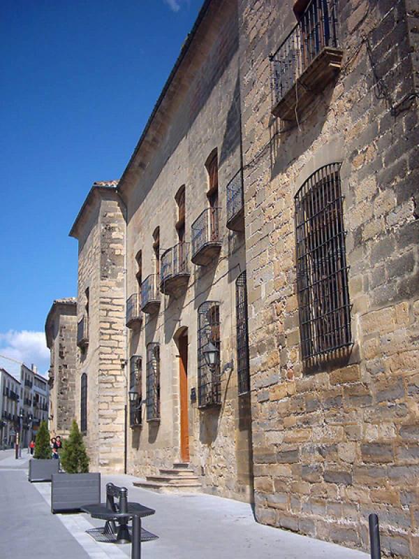
This building was built in 1520 as a prison at the request of Charles I, on account of the poor conditions of the previous prison. In 1559, an extension was added with the construction of the Judge house—for better vigilance. Since 1867 it has housed the City Hall, and in 1917 was declared a landmark.

This work could have been one of the most transcendent of the Andalusian Renaissance, but because of a series of misfortunes, it still has not been completed to this day. Among other things, the vault of the main chapel was ruined after the Lisbon earthquake in 1755. It also suffered changes after the alienation and the occupation by “The Liceo Theater”. Finally between 50th and 70th years of the 20th century, its surroundings were reorganized with the demolition of the houses attached to the church and theater.
This religious building was a hospital for non-infectious diseases and was in operation from 1529 to 1940, when it became a minor school of the Carmelites. Today, only the church is left, since the remaining sections were rebuilt and used as a hotel.

Between the 14th and 15th centuries, construction began on one of the most important parish churches in the new city. It would become the central hub from which one of the most important neighborhoods would form. This is where the nobility from Baeza would establish themselves--building a palace and ancestral homes.

The palace was built by John Rubio of Salcedo at the beginning of the 16th century with Renaissance style and Gothic influence.
This palace was commissioned by the Sanchez Valenzuela family to be built at the end of the 15th century. After being occupied for several generations, the Counts of Gabia gave it away in 1752 to a cloister of the nuns of Saint Francis of Paula of Saint Ildefonso. They enjoyed its use until 1835, when they were expelled with the Confiscation of Mendizabal. It then became the city casino--and still is.
This was built for Mr Ferdinand of Acuña and Valenzuela, and his wife, Mrs Joan of León Navarrete. The building has a mannerist style from the end of the 16th century, and maintains the same model as all the houses on the street. The window is flanked by two ionic pilasters, with the Acuña and the León family’s heraldry, as well as the Cross of Calatrava in the middle.
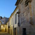
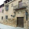
This has been an ancestral home since the beginning of the 16th century. Construction began when the family moved to a neighborhood beyond the wall’s limit. They had given away their previous home in the Cathedral Square to the Council. Today the buildings are known as the High Town Hall. What we can see from the original house is a pure Plateresque-style front, with the Cabrera and Alférez’s heraldic arms.
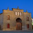
The Bull Ring was built in 1892 with a clearly eclectic language. Neo-Mudejarism was employed as a style, where horseshoe arches predominate. Some materials were reused from churches and also from personal assets that had been abandoned after confiscation.
A building was located here that was used as a school-seminary from the beginning of the 17th century until confiscation, when it was torn down, leaving only the church. Currently it is used as a residential home for the elderly.
This monastery has its origin in the foundation by the Franciscan Friars of the Convent of Saint Lion in the 14th century. It was abandoned years later and then restored by the Saint Clair nuns, who had left the convent at the Saint John neighborhood, for this larger one. That is why, in the façade brickwork, one can observe the evolution of different styles.
This house is one example of the eclectic architecture in Baeza. It was commissioned by the Vela family of Almazán to be built in 1875.

This was founded in 1568 by the presbyter Mr. Nuñez Marcelo as a Monastery of the Order of Saint Augustine. The church, of one single nave, dates from the mid 17th century. It can be accessed through a semicircular arch entrance with a relief of Magdalene the Penitent. In the spandrels, one finds the reliefs of the Faith and Fortress. Inside, standing out in a special way, is the Presence of the Fallen Christ, from the 17th century, a work attributed to Joseph of Mora.
This church is a building of the beginning of the 16th century. It had the title of Collegiate Church from 1764 until 1852.
This convent was found in 1599, the former site of the old Hospital of the Encarnacion.
The first Trinitarian Friars settled in Baeza in 1607, on Platerías Street. In 1615, they were given permission to build the new headquarters.

The construction that gives unity to this building dates from the 15th century, from which date some of the renovations began. The admission gate is from the 13th century, of late-Romanesque style and it is probable that it belonged to another church.
This order was founded at the beginning of the 16th century, and dedicated to heal the sick. In 1791 the Order of Saint Anthony Abad came to an end, with all of the assets moved to the hospital of Virgin Birth. This hospital was destined to become a house for orphaned children.

This tour around the Sevillian poet and his relationship with Baeza will not leave you impassive.
We are at Cardinal Benavides passage, where the historic Town Hall building is located. Here, at the building on the corner of Gaspar Becerra Street, is where Antonio Machado lived with his mother. It is currently private property.

The building we are referring to was the one that would house “The Craftsmen Association” of Baeza on Conception Street. This society disappeared, as well as its building. This is where a literary evening took place with Federico García Lorca.
Almazán’s pharmacy, in which a back room was used to hold literary evenings, where the poet attended frequently, was located on Saint Francis Street, in front of the Ruins of the Convent with the same name, very close to Antonio Machado’s house. This Pharmacy was open until the 70’s of the 20th century; the building where was located was later torn down.
We continue on towards Saint Paul Street and we find in front of the New Casino the seated sculpture of Machado. It is a sculpture that represents the poet reading on a bench at the central Saint Paul Street. This location is one of Baeza’s main hubs and it is a permanent tribute of the city to the poet. Recently built, it was inaugurated in 2009. The sculpture’s artist is Antonio Pérez Mohedano.
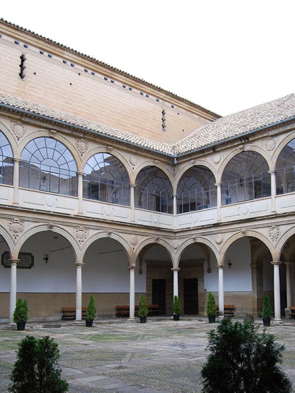
In the 16th century, the University of Baeza was founded. In the 17th century, it was moved to the present location where we stand. During the 17th and 18th centuries it had moments of greatness and magnificence along with others universities of Andalusia: Seville, Granada and Osuna, but in the 19th century it fell into decline, getting its first warning of withdrawal in July 1807. After different revivals and changes in ownership, in 1875 it became a Humanity School that soon would become a Secondary Teaching Institute. Then in 1912, with principal Mr. Leopoldo of Urquía, Antonio Machado arrived in Baeza, missing the passing-away of his wife Leonor.
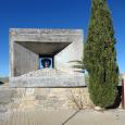
The International University of Andalusia paid tribute to the Sevillian poet on the 70th anniversary of his death, leaving for posterity the “machadiano space”. It consists of one of the gardens’ corners of UNIA headquarters, where the bust of Antonio Machado was set. It is a mid 90’s sculpture sculpted by the artist Melchor Zapata.
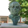
In 1966 a great number of intellectuals wanted to pay tribute to Antonio Machado in Baeza. With the cost defrayed by many volunteers, it was sculpted by Paul Serrano-- a bronze head set on a concrete base, designed by the architect Fernando Ramón. It would be placed on the Stroll of the Walls, where the poet so often took his walks. For that day Joan Miró designed a commemorative poster and a CD was edited, but because of political issues, it wasn’t laid in that place until 17 years later. It was April 10th 1983 when tribute was paid to Machado with the unveiling of the sculpture, located at the Stroll of the Walls, which from that day it was called “The Stroll of Mr. Antonio Machado”.
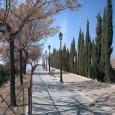
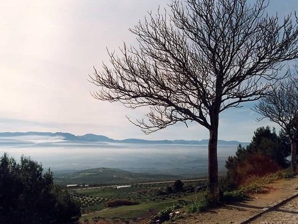
Along this placid Stroll of Mr. Antonio Machado--inaugurated in 1983, strolls can be taken looking at the valley of the Guadalquivir river and the Mágina range summits at the same time that stone sign with poet’s poems can be read.
In order to understand the Baeza of today, we need to go back to the first settlers, and see how from those settlements the city was forming-- until it became a medieval walled metropolis, due to a privileged geographic-defensive location.
The first inhabitants settled at the well-known “Hill of the Alcázar”. Currently is the location of an archaeological site that shows a very lengthy sequence of occupation. It began in the Bronze Age, and later evolved into the Iberian city of Viatia o Vivatia, as the remains show--changing still later to the Roman Age, when Biatia was one of the most important Roman cities, until the arrival of the Muslims, who established the definitive wall limits.
What once was the medieval wall, was consolidated by adding towers and gates that gave way to the city pathways. The names have been preserved as time goes by, like the Gate Toledo, the Gate of Úbeda or the Gate of the Azacaya, this last one also called the Gate of Jaén, which is the place where we are standing.
The remaining walls still standing, date from the Muslim Age, although some parts were rebuilt in the 16th century. In 1476, Queen Elizabeth the Catholic ordered the tearing down of the walls, the towers and gates. Her objective was the end of internal disputes between aristocrat families of the Carvajales and Benavides. Each wanted control of the Council and the Mayor’s office of the Alcazar.
The neighborhoods on the outskirts would rise in a religious environment, among all in the Renaissance period, the most brilliant period of Baeza history. According to Professor Policarpo Cruz: “Baeza acquires its monumental shape as one of the unique nucleus between Andalusia’s mid cities.

The well-known Square of the Lions or the Pópulo’s is one of the most import squares in Baeza. Reorganization was finished in the 70’s, when some of the urban elements were relocated. Before this new distribution, the notorious lower-square was an extension of the Square of the Market or Stroll.
Close to this area, the Square of the Fish was located, with the city inns, where wine, fish and meat were sold.
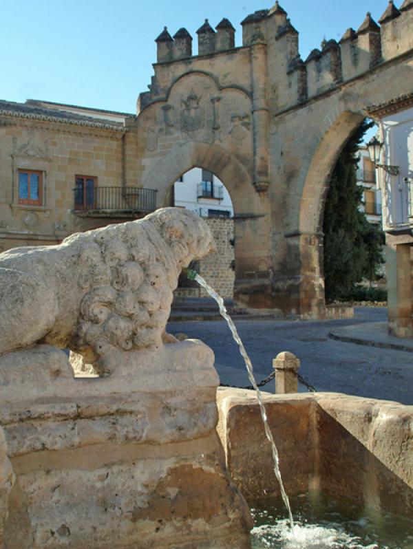
The Gate of Azacaya or Jaén is one of the examples spread through the urban fabric of what once was the medieval walled city. The place where the gate is located was the required way to exit the city towards Jaén, and also the place from where the troops set off to conquer the last Muslim bastion.
The Villalar arch dates from 1521 and commemorates the victory of the imperial troops of Charles I in the Villalar battle over the rebels of Castile. It was commissioned by the Carvajales family, who were loyal to the emperor.
Both were reconstructions after 1476, when Elisabeth the Catholic ordered the tearing down the canvas of the walls, gates and towers. Later, the Gate of Jaén was erected again and was decorated with the imperial and the mayor’s coats of arms for the arrival of Charles I after his honeymoon with Elisabeth of Portugal in 1526, giving this square a representative sign.

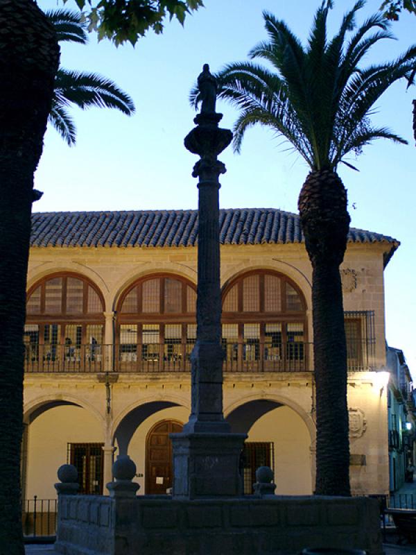
During a great part of the 16th century, this was the main fountain of the city, also known as the basin. It is a mixtilinear basin fountain with curves at the corners, which has two pairs of felines and equines, and a classic feminine figure on top of the column.
According to some historians, these sculptures belong to the nearby Roman city of Cástulo, and the feminine figure would be Imilce, Anibal’s wife (the head was destroyed during the civil war).
This was built around 1535. The wall next to the Gate of Jaén had to be torn down, with the condition of not destroying the chapel of the Virgin of the Pópulo, consolidated as a memory of the first mass that was held after the conquest.
It is a two-story building. The access to the ground floor is from the Square of the Pópulo through six gates, each one corresponding to one notary. It can be observed here the coat of arms of the city, columns and lions as ornaments.
The first floor, or Audience, is accessed through a linteled gate at the back. At the center you can see an imperial coat of arms, accompanied by the judge Guevara and Baeza’s, and five medallions with reliefs of figures of classical times. It is completed off with a much decorated cornice with rosettes, corbels and three gargoyles.
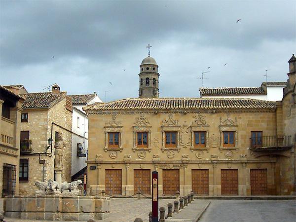
This building was built during the reign of Charles I. Located originally on the city outskirts by way of the Gate of Jaén, it was relocated in the 70’s, by the General Administration of Fine Arts-- to its current location, in order to establish a regular and organized square. The building couldn’t be rebuilt with the same configuration, since the square was shorter than its original emplacement, so the solution was to double the ends folding them over the sides.
It consists of two different parts divided by an entablature decorated with rosettes.
The building was the butcher’s shop, with a slaughterhouse on the ground floor, and a selling area on the first floor. Subsequently it was used as a fur drying shed, local archive, museum and an area for youth. Currently, it is the court headquarters.
The origin of the foundation came from the figure of St John of Ávila, who established, under the title of “the Most Holy Trinity “, the Learning Institutions or Schools of Literature, which in 1542 were transformed into a University, which became the most important in Andalusia. The relocation happened in 1568, leaving this building as a primary school until 1814, when it became a tenement house until 1992, the year in which the Town Hall restored part of it for accommodation and the rest for the Baeza Museum.
The building has reached our days only with the front gate to the chapel with an inscription on the entablature referring to the Most Holy Trinity, and with a vaulted background. The rest has been completely transformed.
The goal of the current Baeza Museum is to add value to the local history, and we can find materials of all periods that constitute the Baeza history, from burial offerings of the Bronze Age to photographs of Domingo López that reproduces the Baeza of the 19th century.
This arch was another access to the city, also known as the Gate of the Learning Institution or the Shutter of Saint Lion, since it is now where the University is now situated. It used to be the location of the chapel of Saint Lion. The name “Bearded man” is due to Martín Yañez of the Barbuda, master of the order of Alcántara, who in 1394 walked through that gate with an important army to fight against the Muslims from Granada, according to the testimony of the oral traditions.
It is built in masonry work, with semicircular openings with radial vous-soirs.
On the left side there is a niche with a canvas of the Virgin with a child with a number of prayers from the bishop Mr. Benito Martín dated in 1758. In all conquered cities, written evidence was left of this feat during the Baroque Counter reformation.
The second University headquarters, was erected in the same place where the chapel of St Lion was situated, to solve the space problems that existed at the first location. The building was finished in 1593, and kept its purposes until 1824 when it was permanently lifted by Royal Decree. Later it was a Humanities School and Free Institute, where Antonio Machado gave classes. Lastly it turned into a Secondary Learning Institution.
The second University headquarters, was erected in the same place where the chapel of St Lion was situated, to solve the space problems that existed at the first location. The building was finished in 1593, and kept its purposes until 1824 when it was permanently lifted by Royal Decree. Later it was a Humanities School and Free Institute, where Antonio Machado gave classes. Lastly it turned into a Secondary Learning Institution.
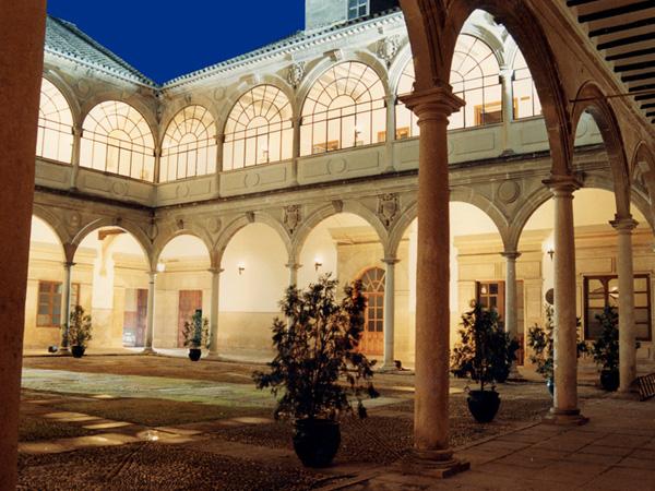
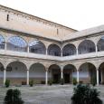
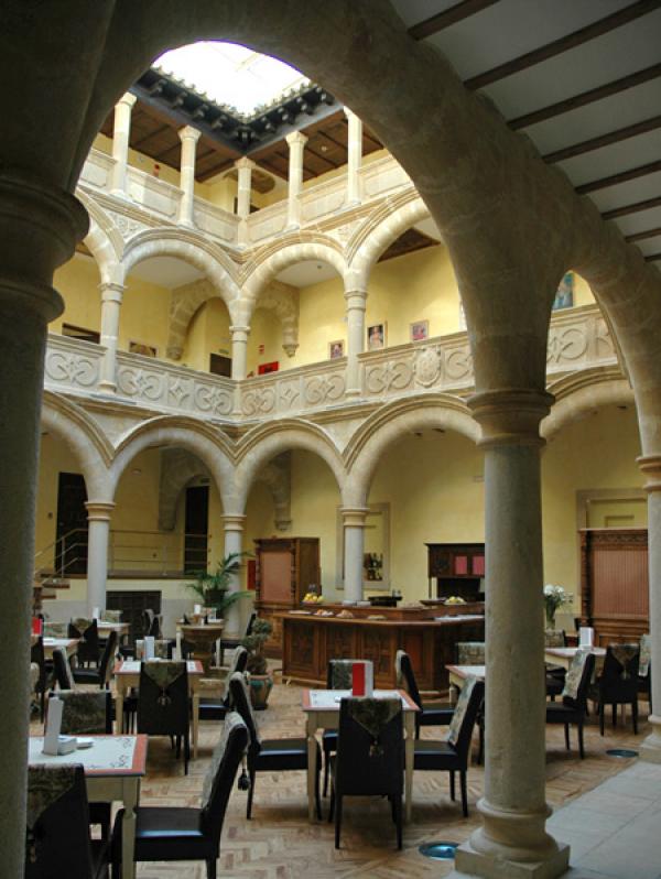
The structure answers to a unique typology from the Renaissance palaces: A big courtyard with double arcade with staircase covered with a paneled dome. In the courtyard we can find the main hall. This complex is completed with the chapel of Saint John the Evangelist, of an only nave with half-barrel vault. The tower rises with a square-shape floor up to the roof level, where it turns into an octagonal shape. The façade is made out of masonry work with Baroque ornament
The classroom where Antonio Machado gave classes, from his arrival in 1912 until 1919, is still preserved in the columned courtyard. In this high Andalusia, where he felt so “humid and cold” at first, he deepened his philosophic roots and wrote an important part of his work.
This construction from the 16th century and created by The Crown, was located in back of the Corn Exchange. The two buildings were connected and this one served as a grain warehouse.
Due to the population increase during the glorious period of the city, the building had to be enlarged. It can be differentiated between the new one and the old one, both built along the barbican.
The remains still standing are some arches of the old vault that gave shape to the building. Currently, most of it has been destined to accommodation, and the rest to a Renaissance interpretation center, with the objective of making a creative learning environment, seeking to reveal to the public the meaning of the cultural and historic legacy of the Renaissance Baeza.
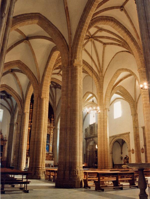
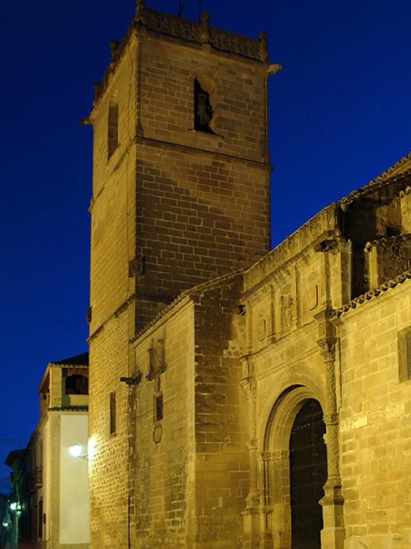
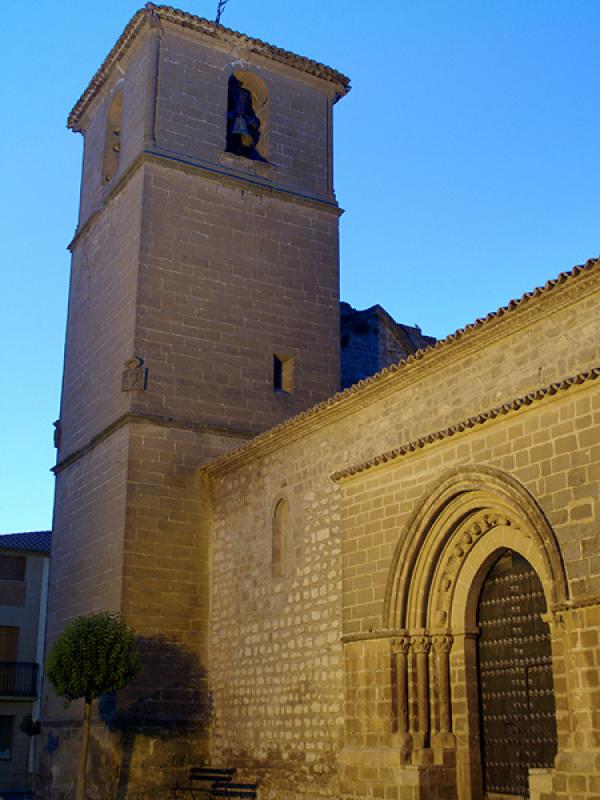
This church of late Romanesque style dates from the 13th century, which is still preserved after the Christian conquest. It has an austere exterior, with two gates standing out with semicircular archivolts. The main part comes from the old Church of Saint John the Baptist.
The interior consists of three naves. In 1990, some mural paintings were discovered dating from the 15th and 16th centuries, which have recently been restored. During the restoration, in the epistle area, a Visigoth style horseshoe arch appeared, which made one think that in this same location, an old Christian temple existed, upon which the current one was built.
Opposite the Church of Saint Cross rises the Palace of Jabalquinto, one of the greatest examples of Elizabethan Gothic style, which was commissioned by John Alfonso of Benavides, second cousin of Ferdinand the Catholic, in the late 15th century.
The Elizabethan Gothic style can be found in the exterior, with ornament which consist of diamond tips, pine cone nails, foliage, flowers, bows, pinnacles, muqarnas and heraldic coats of arms.
The façade is completed off with five semicircular arches from the Renaissance period, as well as the courtyard, from late 16th century. It is made up of a semicircular double series of arches with marble columns. The stairs are fully Baroque.
Today it houses Antonio Machado International University.

The Cathedral is the most representative building in the square. It is believed that, in this location, a Romanesque temple could have existed, later transformed in Visigoth style until the arrival of the Muslims who built the Aljama mosque. In 1227, it became, under the dedication to the Virgin Mary of “The Nativity”, the Cathedral site.
In the 16th century a restoration was carried out, which will give the building a Renaissance touch. The front was designed by John the Baptist Villalpando in 1587, with a relief of “The Nativity of the Virgin”.
The interior contains numerous art objects of great quality, which are exhibited in the Cathedral Museum of the Beautiful Cloister.
It is believed that the tower base was the mosque minaret, adding in the Vandelvira period a belfry level and a roof that fell off in 1862, which was restored with a hipped slate capital, which was changed in the 50’s.
This is a building from the late 15th century, the property of “Hill” Bayle of Cabrera, who gave it away to the Council to house the Town Hall. In 1838, it became the local archive until 1970. In 1991 it became a conservatory, now it is closed waiting to be restored soon.
Between 1511 and 1526 the building was restored and extended due to its terrible state of preservation. That is why two parts can be differentiated in the building, one florid gothic taste, with the coat of arms of the Queen Joan the Mad and Philip the Handsome, and the upper part from the 16th century as a tower, with a gothic window, open during the period of Charles I, as it is shown in the two-headed hawk coat of arms. In addition to the emperor’s coat of arms, the Judge Mr. Álvaro of Lugo´s and the city’s coats of arms can be also observed.
With this building, which house the civil authorities, all the functions which govern a city are completed, located in Baeza’s most important square from the 16th century.

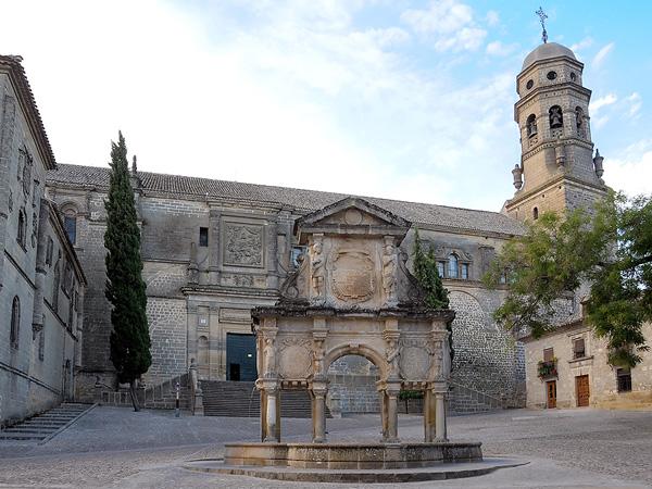
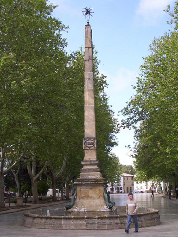
We are standing at the civilian and religious area of the city at that time. That is why this large fountain was built--for the commemoration of the bringing of water to Baeza, as an arch of triumph of Ginés Martínez of Aranda in 1564.
It consists of one of the most delicious and beautiful examples of fountain typologies from the 16th century. It is formed by a triumphal arch support on four pilasters and eight columns, on which another part is set topped with a pediment. It is decorated with the coat of arms of Philip II and five medallions with legible inscriptions.
The seminary was founded in 1660 by Bishop Ferdinand of Andrade and Castro under the management of the Fathers of Saint Philip Neri Oratory. In 1921 the major seminary was moved to Jaén and in 1969 the seminary was permanently closed. In 1990, the building reopened as Antonio Machado University.
Its façade is harsh, of good masonry work, without ornaments, with a semicircular front with the founder’s coat of arms. It is full of cheers with the names of the people that studied there. Its interior it is arranged in three courtyards, two of them are columned.
The eastern façade has another access, also a semicircular arch with the figure of Saint Philip carved in rock that gives way to the chapel.

This palace, dated in 1804, was built by Joseph Cayetano Rubín of Ceballos and it is a sample of Baeza neoclassical architecture.
The interior has been restored and enlarged by the acquisition of adjacent houses. It has a central courtyard and chapel of recent construction.
Some remains still stand from the late Romanesque temple that became at that time, one of the most important parish churches within the city walls, as we see in its naves and apse.
It was open for public worship until 1843; from that date onwards it has been used as a warehouse and stables, until the abandonment and plundering led to its near disappearance. The front remains were moved to the Church of Saint Cross.
It was restored in 2007. The concept of “original space” was brought back as much as possible from what remained--with a basilical shape with three naves and three aspes.
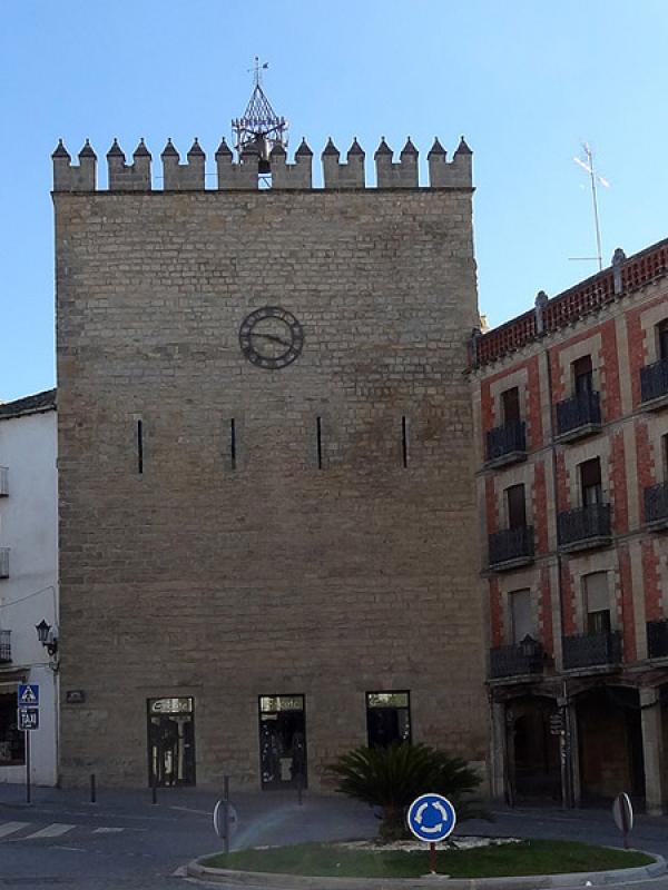
It was without a doubt the best fortified gate from all the walled city. It led to the Úbeda pathway, and in front of which there was a big main square.
It had three arches next to the watchtower from where set off the canvas of walls up to the next towers. Currently, only one is preserved, since the tower and the walls were torn down by orders of the Queen Elizabeth to end the local nobility disputes.
The exterior front of the tower still shows a beautiful coat of arms of the Catholic Kings.
In recent years a commemorative statue has been erected of the two hundred crossbowmen who died in the defense of the city in that same tower.
The Jesuits arrived in Baeza in 1570 and started to build a school having their first headquarters on Mine Street. Years later, due to space problems, they moved to their current location.
The new building started to be built in the last quarter of the 16th century. Soon this building would undergo restorations and extensions, taking advantage of the assignment in 1711 of the area covered by the Gate of the Cañuelo, located at the entrance of the current Company Street.
It was never completely finished, but it opened as a Convent of the Jesuits until their expulsion in 1767. Over time, many pieces of that building were lost. The building was then used as a stud horse barracks in 1841 with the consequential restoration. Nowadays the entrance arches and columns on the sides can be admired, with a clearly Mannerist style.
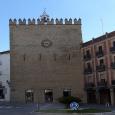
This is one of the most important towers in the Muslim walled enclosure from the 12th century. This is due to its strategic location, since from this tower there was a straight line of sight of the barbican and the torn-down Gate of the Cañuelo (in the current Company street).
It is, in fact, one of the few examples of walled enclosure kept from the demolition by Elisabeth the Catholic in 1476.
It’s 25 meters high and it’s been restored in many occasions. The clock was set in the 19th century, and crowned by the current battlements in the 20th century.
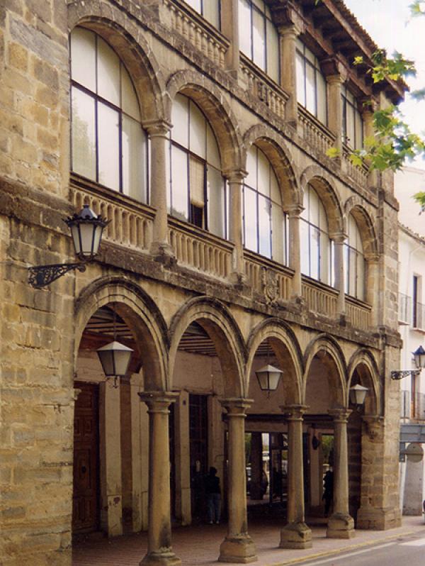
The Corn Exchange is a foundation and local control building. It was erected in the 16th century to give response to the social and economics necessities at that time.
The “Zaida Corn Exchange” was the house used for the sale and contract of grains. Later it was also used as a tavern and inn. In 1955 it was extended with a second story. Currently, it is a private property.
In 1684, judge Ferdinand Ladrón of Guevara proposed to the town council “Look for a place from which to watch bull festivals and to build comedy houses”. Finally after many difficulties this small building is inaugurated in 1701, with a double semicircular arch gallery, with paired columns with a background of Doric capitals. It was a balcony from where bull fights and others festivals could be admired.
The Square of Saint Mary used to house the civilian and religious power, but with the urban development outside the city wall, and relocating the new social center in the Square of the Market, it is proposed to move the Town Hall to this new location. From 1867 the building has been used for Council administrative purposes.
In order to understand the glorious period of Baeza, we need to enter the different neighborhoods which began to emerge after the conquest of the city. The new Christian Baeza started to expand into outskirts-- going past the Medieval walled city line--where new public and private buildings were erected. The religious buildings were the most representative.
Market Square, the new social center, is the internal artery from which the city developed with a radial system of main streets.
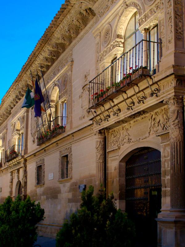
This building was built in 1520 as a prison at the request of Charles I, on account of the poor conditions of the previous prison. In 1559, an extension was added with the construction of the Judge house—for better vigilance. Since 1867 it has housed the City Hall, and in 1917 was declared a landmark.
It is made up of a prison, with a more sober façade with representations of the Justice and the Charity, and the Judge’s home-- with a rich Plateresque decoration. On the top floor, we can find tripartite balconies with the coats of arms of Felipe II, the Judge, and that of the city. The cornice is topped with decorated corbels, standing out with figures.
The Council Hall has a Renaissance wainscoting (a horizontal crisscrossed wooden ceiling) from the Monastery of Saint Anthony.
It is worth mentioning the importance of the construction in the Andalusian Plateresque style, due to its Italian components.
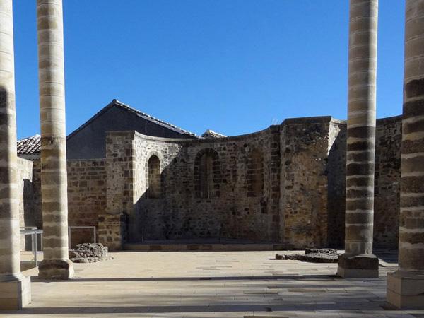
This work could have been one of the most transcendent of the Andalusian Renaissance, but because of a series of misfortunes, it still has not been completed to this day. Among other things, the vault of the main chapel was ruined after the Lisbon earthquake in 1755. It also suffered changes after the alienation and the occupation by “The Liceo Theater”. Finally between 50th and 70th years of the 20th century, its surroundings were reorganized with the demolition of the houses attached to the church and theater.
In this funeral and convent complex, Vandelvira gave the best of his talent. Only the left size of the funerary chapel is preserved, which consist of an altarpiece made out of stones. Two reliefs represent the Adoration of the Kings and the Shepherds. The lower chapels have characteristics of the Old and New Testament.
Still standing is the church of the Latina Cross, which one can access through a semi-circular arch that frames the whole gate. There you will find a relief of Saint Francis and a tondo with the Virgin, that currently gives way to a large auditorium.
The cloister of the convent is also preserved, with triple arcade staircase, nowadays used as a hotel.

This religious building was a hospital for non-infectious diseases and was in operation from 1529 to 1940, when it became a minor school of the Carmelites. Today, only the church is left, since the remaining sections were rebuilt and used as a hotel.
The church was part of an extension project commissioned by Bishop Moscoso in 1625. Inside we can find a relief of the Virgin Mary surrounded by symbols of the Litany. The building opens to Saint Francis Street and has another entrance made up of a four-arch atrium at the corner with Virgin Birth street.
Its interior had only one nave and it’s covered by a half-barrel vault and a semi-circular dome. However, in the 20th century, another section was added, given an L-shape to the church.

Between the 14th and 15th centuries, construction began on one of the most important parish churches in the new city. It would become the central hub from which one of the most important neighborhoods would form. This is where the nobility from Baeza would establish themselves--building a palace and ancestral homes.
The result was a Gothic-style church--with a few other styles which did not affect the overall unity of the building. From the late Renaissance-style gate, a relief stands out with the image of Saint Paul.
Inside, you can make out three pointed-arcade naves with ribbed vault Gothic chapels. The starred-shape ribbed vault, that corresponds to the altar, is the most decorated.
Sculptures, paintings and goldsmithing stands out in this church, as well as its original archive with documents of baptisms dating from 1494-- before the Trenton Council standardized the use of the archives. It also includes the archive of the missing church of Saint Marc.
The palace was built by John Rubio of Salcedo at the beginning of the 16th century with Renaissance style and Gothic influence.
Subsequently, the exterior suffered some modifications, among all, those related to the façade. At present, it is divided into three stories separated by moldings. At the top there is an eave with gargoyles. Above the entrance there is a balcony with the coat of arms of the Salcedo and Ponce of León’s on both sides, and on the upper level there are several coat of arms of Flemish-style.
This palace was commissioned by the Sanchez Valenzuela family to be built at the end of the 15th century. After being occupied for several generations, the Counts of Gabia gave it away in 1752 to a cloister of the nuns of Saint Francis of Paula of Saint Ildefonso. They enjoyed its use until 1835, when they were expelled with the Confiscation of Mendizabal. It then became the city casino--and still is.
The building has suffered some modifications, but it still preserves the concept of a courtyard-house with stairs that stand out along the side. The façade maintains its original appearance of a fortress with two towers on either side, and a linteled gate without ornaments. It is a sober double deck courtyard, in which can be seen a transition between the Gothic and the Renaissance style.
This was built for Mr Ferdinand of Acuña and Valenzuela, and his wife, Mrs Joan of León Navarrete. The building has a mannerist style from the end of the 16th century, and maintains the same model as all the houses on the street. The window is flanked by two ionic pilasters, with the Acuña and the León family’s heraldry, as well as the Cross of Calatrava in the middle.

This has been an ancestral home since the beginning of the 16th century. Construction began when the family moved to a neighborhood beyond the wall’s limit. They had given away their previous home in the Cathedral Square to the Council. Today the buildings are known as the High Town Hall. What we can see from the original house is a pure Plateresque-style front, with the Cabrera and Alférez’s heraldic arms.

The Bull Ring was built in 1892 with a clearly eclectic language. Neo-Mudejarism was employed as a style, where horseshoe arches predominate. Some materials were reused from churches and also from personal assets that had been abandoned after confiscation.

A building was located here that was used as a school-seminary from the beginning of the 17th century until confiscation, when it was torn down, leaving only the church. Currently it is used as a residential home for the elderly.
The shape of the church is a Latin Cross, topped with a barrel vault.
The façade is divided in two parts; the lower part has a semicircular arch with the representations of the Fortress and the Hope with the coat of arms of the bishop Raya. In the upper level of the façade, an important relief stands out between columns which represents the ecstasy of St Ignatitus, with a great number of angels and cherubs. It is completed off with a curb pediment and the Royal coat of arms of the Bourbons.

This monastery has its origin in the foundation by the Franciscan Friars of the Convent of Saint Lion in the 14th century. It was abandoned years later and then restored by the Saint Clair nuns, who had left the convent at the Saint John neighborhood, for this larger one. That is why, in the façade brickwork, one can observe the evolution of different styles.
The access to the church is through a Plateresque semicircular arch gate with the figure of Saint Anthony.
Inside the Friar’s ancient gothic church still stands an arch supported by columns with plant and head decorations. The rest of the church--with one nave and a multi-sided apse-- dates from the 16th century. It used to have a multi-colored ceiling, but this was lost in 1953 during a restoration work. The coffering of the lower choir was moved to the plenary Town Hall, where it is currently located.
The convent has a two-story, late Gothic cloister with arches.
This house is one example of the eclectic architecture in Baeza. It was commissioned by the Vela family of Almazán to be built in 1875.
The façade is divided into two heights. The interior has been transformed, and in the courtyard, one can still see the remains of the arcade that once had risen there.
On the left, there is a Moorish fountain, from the 17th century, which was one of the most important fountains in the city. In the 19th century, it was restored in order to relocate the piping system of the house of Vela of Almazán’s. That is why the decoration date is 1882. The main wall shows the city and royal coat of arms.

This was founded in 1568 by the presbyter Mr. Nuñez Marcelo as a Monastery of the Order of Saint Augustine. The church, of one single nave, dates from the mid 17th century. It can be accessed through a semicircular arch entrance with a relief of Magdalene the Penitent. In the spandrels, one finds the reliefs of the Faith and Fortress. Inside, standing out in a special way, is the Presence of the Fallen Christ, from the 17th century, a work attributed to Joseph of Mora.
This church is a building of the beginning of the 16th century. It had the title of Collegiate Church from 1764 until 1852.
In this building, a the Plateresque style gate stands out next to the square tower. The central niche of the main gate shows the figure of Saint Andrew, flanked by the coat of arms of the bishop responsible for its development.
The interior is a main, spacious nave formed by pointed arches with side chapels. In one of these, you will see the coat of arms of the “Infanzones” that took part in the conquest of Baeza. In the main altar, designed by Vandelvira in the 17th century, was laid the altarpiece of five streets. Sculptures here include The Lady Chapel where one finds the Gothic carving of the Virgin of the Alcazar.
Inside the building, two processional carvings from the XVII century stand out, together with nine Sevillian gothic boards from the second half of the XV century.
This convent was found in 1599, the former site of the old Hospital of the Encarnacion.
The entrance to the church has a semicircular arch between pilasters with a high relief of the Annunciation. The interior of the temple is of one single nave. The Baroque altarpiece stands out with the representation of the Virgin of Carmen, Saint Joseph and paintings of the founders of the order.
Currently, this church is still the Convent of the Barefoot Carmelites.
The first Trinitarian Friars settled in Baeza in 1607, on Platerías Street. In 1615, they were given permission to build the new headquarters.
Outside the building you can admire the squared-tower, finished in the shape of an octagon. The gate has a divided tympanum with the coat of arms of the Trinitarians.
The interior of the building is purely Baroque. This is the only example of an elliptical shape in Baeza. In the 90’s it was restored, with a main concentration of the work being in the central vault. This vault is finished with a plaster cornice, decorated with Baroque plant motifs. This restoration had the title of “Europe Nostra”.
The construction that gives unity to this building dates from the 15th century, from which date some of the renovations began. The admission gate is from the 13th century, of late-Romanesque style and it is probable that it belonged to another church.
In the 16th century, an attempt at an extension was made, but –as one can see from the courtyard--this was never completed. In the 19th century, all of the building was given a neoclassic appearance. This new appearance would later be removed, with the building being brought back to its original appearance during the years 1968 to 1975.
The interior is arranged in the shape of a basilica, and divided in three naves of Gothic-Mudejar style. The great altar with Baroque altarpieces really stands out inside the building.
It has sculptures of great quality, as well as a very interesting bas-relief of the Virgin of Val of Haro.
This order was founded at the beginning of the 16th century, and dedicated to heal the sick. In 1791 the Order of Saint Anthony Abad came to an end, with all of the assets moved to the hospital of Virgin Birth. This hospital was destined to become a house for orphaned children.
A large part of the building was ruined at the end of the 19th century, and the church was lost. The part still standing, which belongs to the hospital, was dedicated as an orphanage, shelter for pilgrims and a tenement house. In a restoration that took place in 1976, the building was used first as house for youngsters, and then later the library and archive. Currently it is still used for the same purpose.
The façade is simple with hardly any ornaments, only a coat or arm of the order, with a “tau” over a two-headed hawk.
Even though the interior has undergone extensive renovation, it still preserves the staircase with a semicircular dome and Baroque pendentives.

This tour around the Sevillian poet and his relationship with Baeza will not leave you impassive.
He is one of the most important poets of Spanish literature, belonging to the Generation of 1898 whose work is classified as Modernism. His contribution was so noteworthy that, on June 22nd 1989, the UNESCO Executive Council, unanimously approved to declare Antonio Machado “the Universal Poet”.
Antonio Machado returned to his native Andalusia after staying with his family in Madrid, after his travels to Paris and after his years as a professor in the Institute of Soria. He arrived in Baeza in 1912, following the death of his wife Leonor, to teach French at Holy Trinity Secondary Teaching School, which is still open today. The importance and repercussion of his work in Baeza was so noteworthy, that it is still considered one of the most prolific and profound periods of his literary activity.
In Baeza, Machado started the notebook published after his death entitled “The Complementaries,” and in 1916 he wrote the poem «To the death of Rubén Darío», who passed away that same year in February.
On June 10th 1916 he met with the young student Federico García Lorca, who was on a study trip along with a group of students from the Granada University, who were also accompanied by professor Dominguez Berrueta. Gathered at the Old University, Machado read them Rubén Darío’s poem. At a literary evening at the Craftsmen Club, García Lorca sang at the piano a variety of popular songs and Machado read his poem «The soil of Alvargonzález».
In October 1919 he obtained a transfer to the Institute of Segovia.
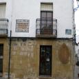
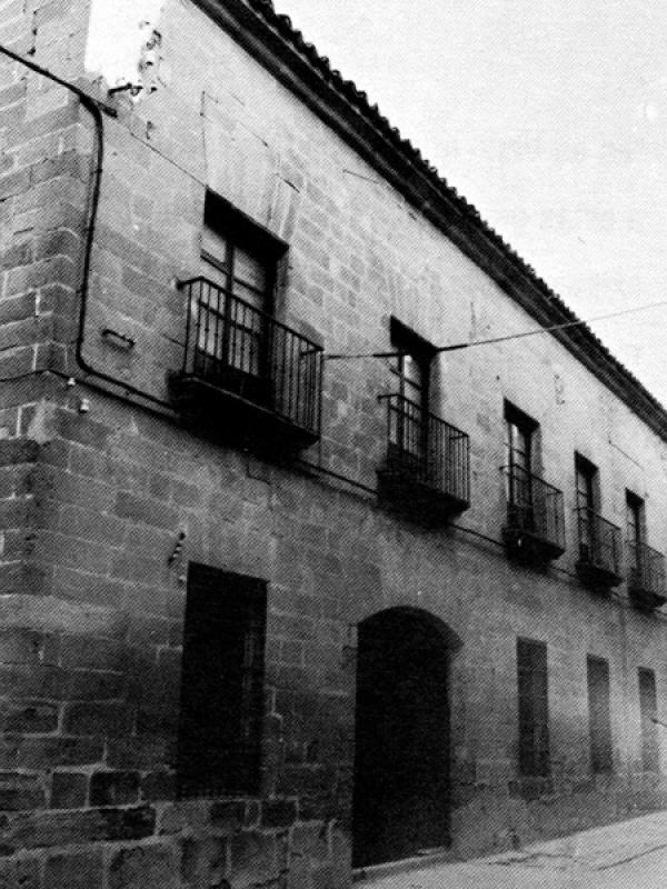
We are at Cardinal Benavides passage, where the historic Town Hall building is located. Here, at the building on the corner of Gaspar Becerra Street, is where Antonio Machado lived with his mother. It is currently private property.
A simple ceramic plaque tells us that the poet once lived here. He arrived at this house after being put up for a period of time in the Commerce hotel, located on the centric Saint Paul Street.
In this scenario, after the death of his wife Leonor, is where his innermost thoughts took place.
From this place Mr. Antonio Machado was off every morning to give French classes, to his literary gatherings and talks. From here he walked downhill to meditate along the pathway that today bears his name: “Mr. Antonio Machado Walk”.

The building we are referring to was the one that would house “The Craftsmen Association” of Baeza on Conception Street. This society disappeared, as well as its building. This is where a literary evening took place with Federico García Lorca.
Almazán’s pharmacy, in which a back room was used to hold literary evenings, where the poet attended frequently, was located on Saint Francis Street, in front of the Ruins of the Convent with the same name, very close to Antonio Machado’s house. This Pharmacy was open until the 70’s of the 20th century; the building where was located was later torn down.

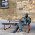
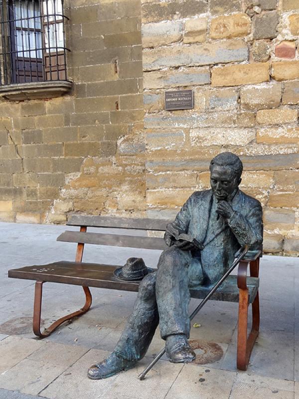
We continue on towards Saint Paul Street and we find in front of the New Casino the seated sculpture of Machado. It is a sculpture that represents the poet reading on a bench at the central Saint Paul Street. This location is one of Baeza’s main hubs and it is a permanent tribute of the city to the poet. Recently built, it was inaugurated in 2009. The sculpture’s artist is Antonio Pérez Mohedano.
In the 16th century, the University of Baeza was founded. In the 17th century, it was moved to the present location where we stand. During the 17th and 18th centuries it had moments of greatness and magnificence along with others universities of Andalusia: Seville, Granada and Osuna, but in the 19th century it fell into decline, getting its first warning of withdrawal in July 1807. After different revivals and changes in ownership, in 1875 it became a Humanity School that soon would become a Secondary Teaching Institute. Then in 1912, with principal Mr. Leopoldo of Urquía, Antonio Machado arrived in Baeza, missing the passing-away of his wife Leonor.
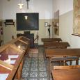
In the columned courtyard, you can find the classroom where he gave French classes until 1919.
The classroom is kept according to how Mr. Antonio lived it: The same hydraulic-tiled floor, the maps of the time hanging on the walls, the students desks, display cabinets with photocopies of documents, the same worn out blackboard and the teacher’s chair; a closet with old books and a coat stand with an umbrella close to a suitcase on a shelf, all recreating the atmosphere of the second half of the 20th century.
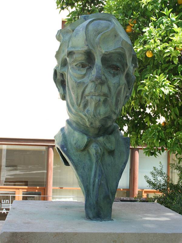
The International University of Andalusia paid tribute to the Sevillian poet on the 70th anniversary of his death, leaving for posterity the “machadiano space”. It consists of one of the gardens’ corners of UNIA headquarters, where the bust of Antonio Machado was set. It is a mid 90’s sculpture sculpted by the artist Melchor Zapata.
In 1966 a great number of intellectuals wanted to pay tribute to Antonio Machado in Baeza. With the cost defrayed by many volunteers, it was sculpted by Paul Serrano-- a bronze head set on a concrete base, designed by the architect Fernando Ramón. It would be placed on the Stroll of the Walls, where the poet so often took his walks. For that day Joan Miró designed a commemorative poster and a CD was edited, but because of political issues, it wasn’t laid in that place until 17 years later. It was April 10th 1983 when tribute was paid to Machado with the unveiling of the sculpture, located at the Stroll of the Walls, which from that day it was called “The Stroll of Mr. Antonio Machado”.

Along this placid Stroll of Mr. Antonio Machado--inaugurated in 1983, strolls can be taken looking at the valley of the Guadalquivir river and the Mágina range summits at the same time that stone sign with poet’s poems can be read.

This project has been supported by:


Project developed by:

Bluehertz Audio Guides
Baeza - 2012
 Map
Map